Posts

Showing posts with the label ASP Update

#AustinSidewalkProject Update: May 2023

Image
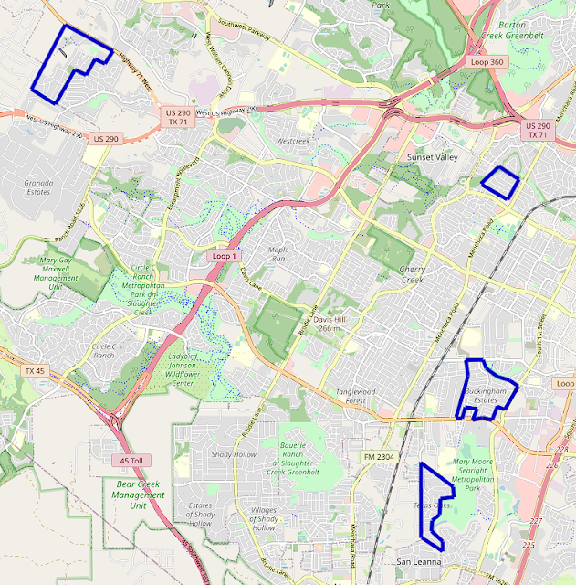
ASP Overview Long time no see. The past few months have been very busy, and very little notable progress was made on the project. But it's summer now, and a goal has been set: map every sidewalk in South Austin by the end of August. Let's see what progress has been made to that end. In May, the project mapped sidewalks in several neighborhoods along South 1st Street, pushing towards the completion of all sidewalks south of Ben White and west of I-35. Long-dormant neighborhoods at the road's southern end were finally completed, and new areas further north were begun. OpenStreetMap view of South-Far South Austin. Neighborhoods mapped in May 2023 in blue. Far South South 1st Completing the cluster of neighborhoods at South 1st Street's southern end, Knolls of Slaughter Creek was mapped in full this May. The neighborhood, with its horse-themed street names and winding layout, has sidewalks on both sides of every road. That's more common in this part of Austin than in ot...

#AustinSidewalkProject Update: December 2022

Image
ASP Overview This December, the project pushed further east than ever before, reaching several new neighborhoods in South Austin. Sidewalks were mapped east of South 1st Street for the first time, with multiple neighborhoods along its route being completed this month. OpenStreetMap view of South-Far South Austin. Neighborhoods mapped in December 2022 in blue. Far South FM 1626 There may not be a cohesive term for the neighborhoods at the end of South 1st Street, but two of them were mapped in full this month. Ashbrook and Meadows at Double Creek, both relatively small neighborhoods, sit at the southern edge of Austin city limits and are relatively unremarkable. Both have sidewalks on both sides of every street, which is nice and somewhat uncommon. FM 1626 doesn't have any sidewalks or crossings here, so despite being directly adjacent, the neighborhoods are quite disconnected. At least South 1st has bike lanes, albeit unprotected ones. OpenStreetMap view of Ashbrook and Meadows at ...

#AustinSidewalkProject Update: November 2022

Image
ASP Overview The project expanded into and completed several neighborhoods around South Austin over the course of November. Some of the furthest west neighborhoods in the project's scope were completed in Oak Hill, and the sidewalks of several neighborhoods down Slaughter Lane were mapped in full. OpenStreetMap view of South-Southwest Austin. Neighborhoods mapped in November 2022 in blue. Southwest Oak Hill The Covered Bridge and Enclave at Covered Bridge sidewalks were completed, pushing the project further down TX-71 and reaching the western edge of Austin city limits. Most of Covered Bridge and all of Enclave at Covered Bridge have sidewalks on both sides of their streets, relatively uncommon in the area. All crosswalks in Enclave at Covered Bridge are marked, which is quite rare in Southwest Austin. OpenStreetMap view of Covered Bridge and Enclave at Covered Bridge. Austin city limits in orange, Covered Bridge neighborhoods boundary in blue. The Covered Bridge neighborhoods are...