#AustinSidewalkProject Update: May 2023
ASP Overview
Long time no see. The past few months have been very busy, and very little notable progress was made on the project. But it's summer now, and a goal has been set: map every sidewalk in South Austin by the end of August. Let's see what progress has been made to that end.
In May, the project mapped sidewalks in several neighborhoods along South 1st Street, pushing towards the completion of all sidewalks south of Ben White and west of I-35. Long-dormant neighborhoods at the road's southern end were finally completed, and new areas further north were begun.
Far South
South 1st
Completing the cluster of neighborhoods at South 1st Street's southern end, Knolls of Slaughter Creek was mapped in full this May. The neighborhood, with its horse-themed street names and winding layout, has sidewalks on both sides of every road. That's more common in this part of Austin than in other areas of the city, but it's still nice to see. However, the sidewalks are completely disconnected from anything outside the neighborhood; FM 1626 at the southern end of Knolls has no sidewalks, and the Wayne Riddell Loop connection to South 1st Street is still under construction. The neighborhood, at the literal southern edge of the City of Austin, is remarkably isolated from the pedestrian realm.
 |
| OpenStreetMap view of Knolls of Slaughter Creek. Austin city limits in Orange, Knolls of Slaughter Creek neighborhood boundary in blue. |
I don't think people really consider the Southpark Meadows area "Far South Austin," but based on my system, it is. So the next neighborhood mapped this month stays in this section. Reserve at Southpark Meadows, built in the late 2000s, also has sidewalks on both sides of every street. And unlike Knolls, it is very well connected to the outside world; the neighborhood is tucked between South 1st Street and Slaughter Lane, both of which actually have sidewalks. As the name implies, it's also directly adjacent to the Southpark Meadows shopping center, although that's not the most walkable strip mall in the world.
Also, the last street of The Oak at Twin Creeks was finished in May. It's one small cul-de-sac tucked off of South 1st, but it counts.
 |
| OpenStreetMap view of Reserve at Southpark Meadows and The Oak at Twin Creeks' northern section. Reserve at Southpark Meadows in blue, The Oak at Twin Creeks in green. |
South
Slaughter
After completing essentially every neighborhood surrounding it, Park Ridge was mapped in full this May. Continuing a trend in this update, every street has sidewalks on both sides. The neighborhood has a relatively walkable layout, and is just across Slaughter Lane from Southpark Meadows and the neighborhood previously discussed. On the neighborhood's northern edge, Ralph Ablanedo Drive has a sidewalk, connecting Park Ridge to the pedestrian realm on both ends.
Rather than choosing if this group of neighborhoods belongs more to South 1st or South Congress, they've been bundled with Meadow Lea Drive. The northern portion of Beaconridge was finally mapped, with most streets having sidewalks on both sides (though not all.) The Meadow Creek neighborhood to Beaconridge's east was also completed, with again nearly all of its streets having complete sidewalk coverage. Small portions of other neighborhoods were mapped, including Sunridge South and Buckingham Ridge, but not in full. Additionally, the modern infill development at 7300 South Congress had its sidewalks mapped, though only one street - the aforementioned Meadow Lea Drive - had any.
 |
| OpenStreetMap view of several neighborhoods around Meadow Lea Drive. Beaconridge's northern section in blue, Meadow Creek in green, and 7300 South Congress in magenta. |
William Cannon
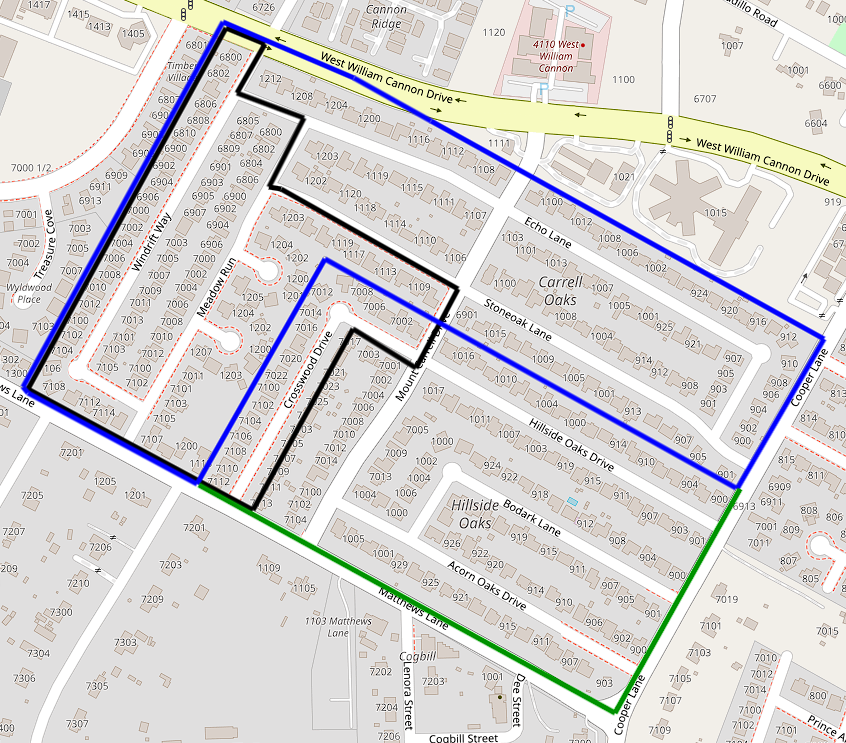
The final two neighborhoods of this month's update are Carrell Oaks and Hillside Oaks, which wrap around each other at the junction of William Cannon Drive and Cooper Lane. While the latter has sidewalks on both sides of every street, Carrell Oaks has an odd amount of road sections with no sidewalks at all. A street like Echo Lane will go from sidewalks on both sides, to nothing, and back, all within a few hundred feet. That's better than the neighborhoods with no sidewalks, which don't get covered in these updates (though they do exist,) but not much.


Comments
Post a Comment