#AustinSidewalkProject Update: November 2022
ASP Overview
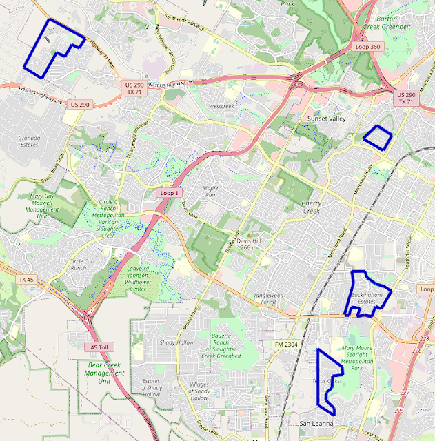
The project expanded into and completed several neighborhoods around South Austin over the course of November. Some of the furthest west neighborhoods in the project's scope were completed in Oak Hill, and the sidewalks of several neighborhoods down Slaughter Lane were mapped in full.
 |
| OpenStreetMap view of South-Southwest Austin. Neighborhoods mapped in November 2022 in blue. |
Southwest
Oak Hill
The Covered Bridge and Enclave at Covered Bridge sidewalks were completed, pushing the project further down TX-71 and reaching the western edge of Austin city limits. Most of Covered Bridge and all of Enclave at Covered Bridge have sidewalks on both sides of their streets, relatively uncommon in the area. All crosswalks in Enclave at Covered Bridge are marked, which is quite rare in Southwest Austin.
 |
| OpenStreetMap view of Covered Bridge and Enclave at Covered Bridge. Austin city limits in orange, Covered Bridge neighborhoods boundary in blue. |
The Covered Bridge neighborhoods are on a significant (albeit unnamed) hill, with many homes needing large retaining walls on their property and some homes only accessible from shared driveways due to the steep slope. This makes for quite steep sidewalks, but at least somebody uses them, based on the Street View image below.
 |
| Shared driveway on Moccasin Path with six homes. Image from Google Maps. |
Sidewalks in the small Valley View Village condominiums complex were completed as well, connecting to some newly built sidewalks on Silvermine Drive.
South
Westgate
Most neighborhoods in the Westgate area have already been mapped, or lack sidewalks entirely. A few sidewalks remained unmapped in Southern Oaks, along Buffalo Pass and Jones Road, but those are done now. Neighboring neighborhood Fairmont Park was checked and has no sidewalks, unfortunately.
Slaughter
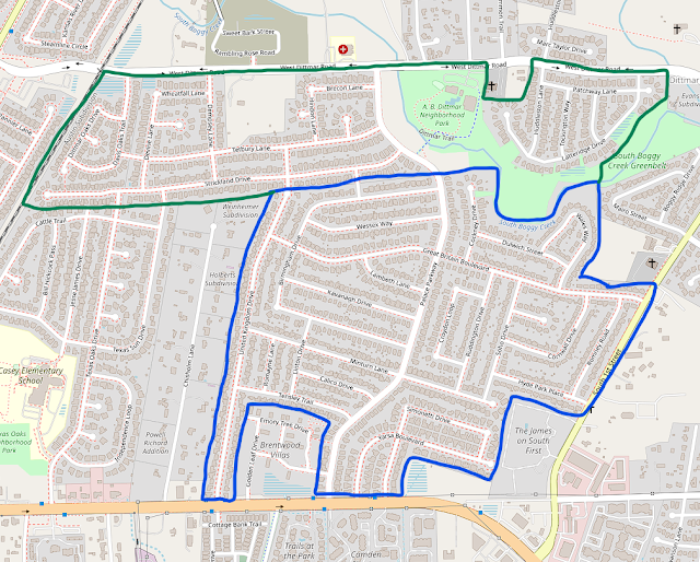
Two of the largest neighborhoods along Slaughter Lane between MoPac and I-35 were mapped in November. The sidewalks of Texas Oaks, the northernmost of which had been mapped earlier this year, were completed south of Slaughter Creek Tributary 1. Most streets in Texas Oaks only have sidewalks on one side, but wider roads within the neighborhood have sidewalks on both. Bilbrook Place even has (unprotected) bike lanes north of North Platt River Drive.
 |
| OpenStreetMap view of the southern portion of Texas Oaks. Austin city limits in orange, Texas Oaks neighborhood boundary in blue. |
On the north side of Slaughter Lane, the largest parts of the Parkwood and Buckingham Estates neighborhoods were mapped. All streets in Parkwood have sidewalks on both sides, while only a few roads in Buckingham Estates do. The mapping of Buckingham Estates extends the sidewalks in South Austin to South 1st Street for the first time in the ASP.
The eastern portion of Parkwood hasn't been mapped yet - that's a target for December. Same goes for the northern portion of Buckingham Estates, which is over half a mile away from its southern half, for whatever reason.


Comments
Post a Comment