Posts

AISD School Schedules Are Weirdly Diverse

Image
Important distinction : I'm talking about the structure of classes in a week here, not the structure of periods within a day. Bell schedules don't say much about a school. I'm not sure these maps say much, either, but they're more interesting. The high school map is so simple that making it at all felt like a waste of time. All the zoned high schools in the Austin Independent School District have the same schedule every week. All of these schools use a block A/B day schedule. Mondays and Wednesdays are always A days, Tuesdays and Thursdays are always B days, and Friday rotates between being an A or B day week by week. As far as I know, Fridays are the same A/B day for every school in the district in a given week.  [This is wrong. A reader of the blog (didn't know I had those!)  let me know that after a schedule disruption, each campus chooses if Friday should be an A or B day, so the schools will probably fall out of sync in a few weeks.] Each week is ABABA or ABABB...

It's The Fourth of July, and Britain Is Poor

Image
We have left the United Kingdom in the economic dust. Every single state in these United States has a higher median household income than the United Kingdom. 247 years after we declared independence, the UK has similar wealth to Cape Girardeau, Missouri. It's a nice town, but that is deeply embarrassing for a nation that once ruled a fourth of the world. This sucks, guys. There are several states in this country that are punchlines. Those states are still richer than the United Kingdom. The median  home in Washington D.C, a city known not long ago for crippling poverty and decline, makes twice as much as the UK's median household. Not a single postcode area in the United Kingdom can claim that. And Washington is far from the richest place in America. Parts of this country, mostly in the South, are poorer than the United Kingdom. But there are also counties where the median household income is three times  that of the UK. Nearly every major city has an outlying county or two wi...

Austin ISD 2022-23 Enrollment, and a Test of Datawrapper

Image
I've made some very simple maps with Datawrapper, but I can see that it's a very powerful tool, and I want to test its embed functionality. So here; the enrollment of every zoned school in the Austin Independent School District. The average size of the elementary schools is heavily skewed by Blazier, which has two campuses and is very much an outlier. There are dozens of elementaries that are tiny, and should probably be consolidated, but every attempt to actually do that has been extremely controversial in the past. Some of the city's smallest schools are actually getting tens of millions of new investments as part of the recently passed 2022 Bond, like Oak Springs and Wooten. The middle schools are an interesting bunch. The two smallest of the lot, Martin and Mendez, only offer 7th & 8th grades, which makes them appear smaller than they should be. But before they dropped 6th grade about three years ago, they were already the two smallest. The largest, Gorzycki, is als...

#AustinSidewalkProject Update: May 2023

Image
ASP Overview Long time no see. The past few months have been very busy, and very little notable progress was made on the project. But it's summer now, and a goal has been set: map every sidewalk in South Austin by the end of August. Let's see what progress has been made to that end. In May, the project mapped sidewalks in several neighborhoods along South 1st Street, pushing towards the completion of all sidewalks south of Ben White and west of I-35. Long-dormant neighborhoods at the road's southern end were finally completed, and new areas further north were begun. OpenStreetMap view of South-Far South Austin. Neighborhoods mapped in May 2023 in blue. Far South South 1st Completing the cluster of neighborhoods at South 1st Street's southern end, Knolls of Slaughter Creek was mapped in full this May. The neighborhood, with its horse-themed street names and winding layout, has sidewalks on both sides of every road. That's more common in this part of Austin than in ot...

#AustinSidewalkProject Update: December 2022

Image
ASP Overview This December, the project pushed further east than ever before, reaching several new neighborhoods in South Austin. Sidewalks were mapped east of South 1st Street for the first time, with multiple neighborhoods along its route being completed this month. OpenStreetMap view of South-Far South Austin. Neighborhoods mapped in December 2022 in blue. Far South FM 1626 There may not be a cohesive term for the neighborhoods at the end of South 1st Street, but two of them were mapped in full this month. Ashbrook and Meadows at Double Creek, both relatively small neighborhoods, sit at the southern edge of Austin city limits and are relatively unremarkable. Both have sidewalks on both sides of every street, which is nice and somewhat uncommon. FM 1626 doesn't have any sidewalks or crossings here, so despite being directly adjacent, the neighborhoods are quite disconnected. At least South 1st has bike lanes, albeit unprotected ones. OpenStreetMap view of Ashbrook and Meadows at ...

#AustinSidewalkProject Update: November 2022

Image
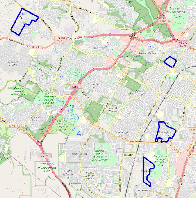
ASP Overview The project expanded into and completed several neighborhoods around South Austin over the course of November. Some of the furthest west neighborhoods in the project's scope were completed in Oak Hill, and the sidewalks of several neighborhoods down Slaughter Lane were mapped in full. OpenStreetMap view of South-Southwest Austin. Neighborhoods mapped in November 2022 in blue. Southwest Oak Hill The Covered Bridge and Enclave at Covered Bridge sidewalks were completed, pushing the project further down TX-71 and reaching the western edge of Austin city limits. Most of Covered Bridge and all of Enclave at Covered Bridge have sidewalks on both sides of their streets, relatively uncommon in the area. All crosswalks in Enclave at Covered Bridge are marked, which is quite rare in Southwest Austin. OpenStreetMap view of Covered Bridge and Enclave at Covered Bridge. Austin city limits in orange, Covered Bridge neighborhoods boundary in blue. The Covered Bridge neighborhoods are...